eMoviePoster.com
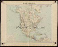
Auction History Result 4j604 NORTH AMERICA French 21x27 map 1889 wonderful Giffault map of the continent! Date Sold 10/18/2012Sold For: Login or Register to see sold price. An Original Vintage Folded French Map (measures 21" x 26 1/2" [53 x 67 cm]) (Learn More) North America, the circa late 1890s French world atlas map featuring lithographic art of North, Central and parts of South America as it appeared in the late 19th Century, drawn by E. Giffault with lettering by Victor Huot and engraved by E. Delaune. If anyone knows more about this map, please e-mail us and we will post it here. Artist: E. Giffault Important Added Info: Note that this map is an original 1889 map that has been removed from a larger atlas! Also note that the map was folded down the middle (because it was part of a book) but has been laying flat for a long time and will be sent rolled in a tube. Condition: very good. Part of the book binding is still attached to the poster along the foldline on the back. There are minor creases and areas of light rippling around the edges of the map. The map is otherwise in very nice condition, especially considering its age and it displays well! Learn More about condition grades 

Postal Mailing Address:
Bruce Hershenson, P.O. Box 874, West Plains, MO 65775. (For our UPS or FedEx address, click here) phone: +1 417 256-9616 fax: +1 417 257-6948 E-mail: Contact Us Hours of Operation: Monday - Friday 8:30 AM - 12:00 PM & 1:00 PM - 5:00 PM (CDT) |
|||||||||||||